|
Posted by: thepinetree on 05/04/2024 06:35 PM
Updated by: thepinetree on 05/04/2024 06:35 PM
Expires: 01/01/2029 12:00 AM
:
Chain Controls on Hwys 4, 108 & 88
Arnold, CA...This highway information is the latest reported by Caltrans as of Saturday, May 4th, 2024 at 06:15 PM.
SR 4
[IN THE CENTRAL CALIFORNIA AREA]
Is closed from 0.7 mi east of Lake Alpine to 7.2 mi west of the Jct of SR 89 (Alpine Co) - For the winter - Motorists are advised to use an alternate route
Chains are required on all vehicles except 4-wheel-drive vehicles with snow tires on all 4 wheels from 3.5 mi east of Murphys (Calaveras Co) to the Mt Reba Turnoff (Alpine Co)
Please research chain control locations as Caltrans is currently working to update chain control descriptions for consistency with internet mapping, like Google Maps & Mapquest
SR 88
[IN THE CENTRAL CALIFORNIA AREA & SIERRA NEVADA]
Chains are required on all vehicles except 4-wheel-drive vehicles with snow tires on all 4 wheels from 9 mi east of Pine Grove (Amador Co) to 1 mi west of Woodfords (Alpine Co)
Please research chain control locations as Caltrans is currently working to update chain control descriptions for consistency with internet mapping, like Google Maps & Mapquest
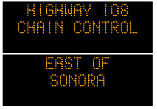
SR 108
[IN THE CENTRAL CALIFORNIA AREA & SIERRA NEVADA]
Is closed from 26.4 mi east of Strawberry (Tuolumne Co) to 7.7 mi west of the Jct US 395 (Mono Co) /Sonora Pass/ - For the winter - Motorists are advised to use an alternate route
Chains are required on all vehicles except 4-wheel-drive vehicles with snow tires on all 4 wheels from 6 mi east of Sonora to 26.4 mi east of Strawberry (Sonora Pass)
Please research chain control locations as Caltrans is currently working to update chain control descriptions for consistency with internet mapping, like Google Maps & Mapquest
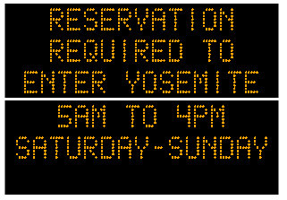
[YOSEMITE NAT'L PARK] For Yosemite Nat'l Park road information call 209-372-0200
SR 120
[IN THE CENTRAL CALIFORNIA AREA & SIERRA NEVADA]
Is closed from Crane Flat to 4.5 mi west of the Jct of US 395 /Tioga Pass/ (Mono Co) - For the winter - Motorists are advised to use an alternate route
[YOSEMITE NAT'L PARK]
For Yosenite Nat'l Park road information call 209-372-0200
|
| Comments - Make a comment |
| The comments are owned by the poster. We are not responsible for its content. We value free speech but remember this is a public forum and we hope that people would use common sense and decency. If you see an offensive comment please email us at news@thepinetree.net
|
|
|


