Posted by: thepinetree on 01/12/2010 05:46 AM
Updated by: thepinetree on 01/14/2010 07:43 AM
Expires: 01/01/2015 12:00 AM
:
Heavy Winter Storm to Bring Welcome Snow To High Country
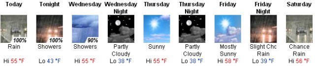
Avery, CA...The first significantly wet winter storm in several weeks is expected to start rolling through soon. From the National Weather Service is the forecast for higher elevations....Today: Snow. High near 37. Breezy, with a south wind between 14 and 22 mph, with gusts as high as 30 mph. Chance of precipitation is 100%. Total daytime snow accumulation of 5 to 9 inches possible...
 
Above is graphics for lower and higher elevations for this storm...
Tonight: Snow. Low around 29. South southwest wind between 14 and 20 mph, with gusts as high as 26 mph. Chance of precipitation is 100%. New snow accumulation of 9 to 13 inches possible.
Wednesday: Snow showers. Temperature rising to near 35 by 11am, then falling to around 24 during the remainder of the day. Southwest wind between 8 and 14 mph, with gusts as high as 18 mph. Chance of precipitation is 90%. New snow accumulation of 5 to 9 inches possible.
Wednesday Night: Mostly cloudy, with a low around 21. Calm wind becoming northeast between 7 and 10 mph.
Thursday: Mostly sunny, with a high near 47. East northeast wind between 11 and 14 mph, with gusts as high as 18 mph.
Thursday Night: Partly cloudy, with a low around 28.
Friday: Mostly sunny, with a high near 49.
Friday Night: Mostly cloudy, with a low around 29.
Saturday: A chance of snow. Mostly cloudy, with a high near 41.
Saturday Night: A chance of snow. Mostly cloudy, with a low around 28.
Sunday: A chance of snow. Mostly cloudy, with a high near 36.
Sunday Night: Snow likely. Cloudy, with a low around 26.
M.L.King Day: Snow likely. Cloudy, with a high near 34.
|


