| Announcements |
Video from Kevin Strey of California Outdoor Adventures of this Afternoon's Storm |
|
Posted by: thepinetree on 04/21/2022 10:29 PM
|
Valley Springs, CA...This is Kevin's video from the Valley Springs area during and after the tornado warning and the storm passed through this afternoon.
|
|
| 5 Comments
|
|
Winter Storm Watch Starting Wednesday Afternoon into Thursday |
|
Posted by: thepinetree on 12/06/2021 06:21 PM
|
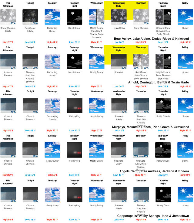
Arnold, CA....The National Weather Service is forecasting a Winter Storm Watch starting Wednesday afternoon..."Winter storm will bring mountain snow late Wednesday afternoon into Thursday. A storm system will approach northern California on Wednesday afternoon, bringing with it accumulating snowfall into Thursday afternoon. Snow levels start out 6000 to 7000 feet falling to 4500 to 5500 feet Thursday morning. The heaviest snow is expected Wednesday night into Thursday morning with the majority of the accumulation above 5500 feet but some light accumulation is possible down to 4500 feet. If you have mountain travel plans be prepared for winter driving conditions, chain controls, and travel delays.
 |
|
Read More
| 1 Comments
|
|
A Beautiful Thanksgiving Weather Week Awaits for West Slope & Mother Lode |
|
Posted by: thepinetree on 11/21/2021 10:20 AM
|
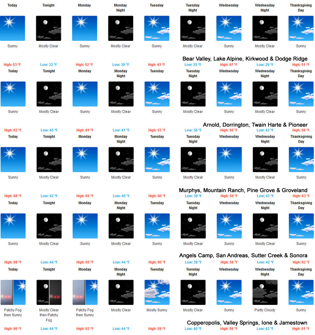
Arnold, CA...The National Weather Service in Sacramento says we have an almost perfect Thanksgiving weather week ahead. The complete forecasts are below...
 |
|
Read More
| 6 Comments
|
|
Red Flag Warning & Blustery Winds Tomorrow Through Tuesday |
|
Posted by: thepinetree on 10/10/2021 10:20 AM
|
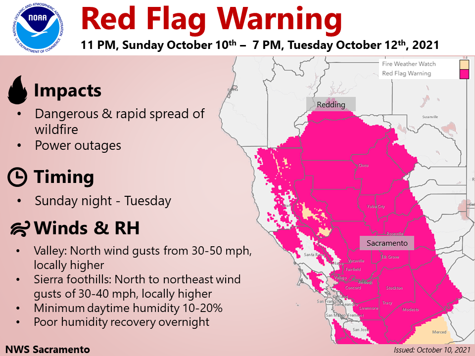
Sacramento, CA...Red Flag Warning late this evening into Tuesday evening for the Central Valley, Coast Range, and the foothill and lower elevations of the southern Cascades...and Monday afternoon into Tuesday evening across the northern Sierra foothills. Gusty north to northeast winds will develop late tonight and continue through Tuesday across much of interior Northern California. The strongest, most impactful, winds are expected on Monday across the Central Valley and foothills of the Coast Range. These winds combined with low humidity and dry fuels will lead to critical fire weather conditions into Tuesday evening.
 |
|
Read More
| 10 Comments
|
|
Red Flag Warning Through August 5th Evening |
|
Posted by: thepinetree on 08/04/2021 10:31 PM
|
Sacramento, CA...The Red Flag Warning has been expanded for portions of Northern California for this afternoon - tomorrow evening. Breezy winds & extremely dry conditions will create critical fire weather conditions. Are you prepared for wildfire? Visit readyforwildfire.org for preparedness tips. The full Red Flag Warning is below...
 |
|
Read More
| 6 Comments
|
|
NWS Issues Excessive Heat Watch for Friday Through Monday! |
|
Posted by: thepinetree on 07/07/2021 08:27 AM
|
Arnold, CA....The latest, updated excessive heat watch from the National Weather Service in Sacramento. "Dangerously hot conditions may impact the Central Valley and surrounding foothills and mountains. Triple digit heat along with warm overnight lows are possible late this week and into early next week. The combination of the very hot afternoons and warm nights will result in a period of high to very high heat risk. Consequently, an Excessive Heat Watch is in effect Friday through Monday evening.
 |
|
Read More
| 0 Comments
|
|
Keep Those Sweaters Handy! Much of our Area will Only See Low Triple Digits. |
|
Posted by: thepinetree on 06/27/2021 11:49 AM
|
Sacramento, CA...In the latest head warning from NWS Sacramento there is at least a sliver of good news for us. Even our lower elevation communities will be over 10 degrees cooler than some northern valley communities. From the NWS..."Another Excessively Hot Day is in store for the central and northern Sacramento Valley. Daily record highs may be set across the northern Sacramento Valley where highs will once again be above 110 degrees, 🌡️ Practice heat safety!"
 |
|
| 0 Comments
|
|
Excessive Heat Warning Extended Through Sunday! |
|
Posted by: thepinetree on 06/19/2021 10:21 AM
|
Arnold, CA...National Weather Service Sacramento has extended their Excessive Heat Warning through Sunday at 8pm. Dangerously hot conditions continue for northern California. High pressure over the west will result in very hot daytime temperatures through the weekend. These hot afternoon temperatures, combined with warm overnight lows, will lead to widespread high to very high heat risk. The Complete Warning is below...
 |
|
Read More
| 0 Comments
|
|
Attorney General Bonta Calls on SEC to Require U.S. Companies to Disclose Financial Risk from Climate Change |
|
Posted by: News_Desk on 06/16/2021 11:00 PM
|
Oakland, CA... California Attorney General Rob Bonta last Monday, the 14th led a coalition of 12 attorneys general in urging the Securities and Exchange Commission (SEC) to require U.S. companies to provide detailed and accurate information about the financial risk they face from climate change. The need to mandate such disclosures is urgent and falls squarely within existing SEC authority. In the past five years alone, climate change-related weather events cost U.S. companies more than $600 billion in direct economic damages. Mandatory climate change-related disclosures are essential to insulate U.S. and global financial systems from systemic risk associated with climate change and to protect investors, including the many ordinary Americans whose retirement savings are largely investment-based.
 |
|
Read More
| 0 Comments
|
|
Hogan Observation Point Fuels Reduction |
|
Posted by: News_Desk on 05/18/2021 02:34 PM
|
San Andreas, CA... The California Department of Forestry and Fire Protection (CAL FIRE) Tuolumne-Calaveras Unit (TCU) will be conducting a hazardous fuel reduction burn near the Observation Point area of New Hogan Reservoir in Valley Springs on Thursday, May 20, 2021.

|
|
Read More
| 0 Comments
|
|


