|
Posted by: thepinetree on 01/27/2011 11:06 AM
Updated by: Kim_Hamilton on 01/27/2011 01:17 PM
Expires: 01/01/2016 12:00 AM
:

Snow Back In The Forecast..... Still Great Weather to Go Outside and Play!
Bear Valley, CA...At least a smidgen of snow is back in the forecast for higher elevations. Today: Sunny, with a high near 54. East northeast wind between 3 and 5 mph. Tonight: Mostly clear, with a low around 31. East northeast wind around 7 mph. Friday: Sunny, with a high near 54. Northeast wind between 5 and 7 mph. Friday Night: Mostly clear, with a low around 28. East wind around 7 mph. Saturday: Mostly sunny, with a high near 46. South southeast wind between 6 and 10 mph. Saturday Night: Mostly cloudy, with a low around 26. Sunday: A 30 percent chance of snow. Partly sunny, with a high near 31. Little or no snow accumulation expected. Sunday Night: Mostly clear, with a low around 23. Monday: Sunny, with a high near 39. Monday Night: Mostly clear, with a low around 24. Tuesday: Sunny, with a high near 43. Tuesday Night: Mostly clear, with a low around 25. Wednesday: Sunny, with a high near 45...
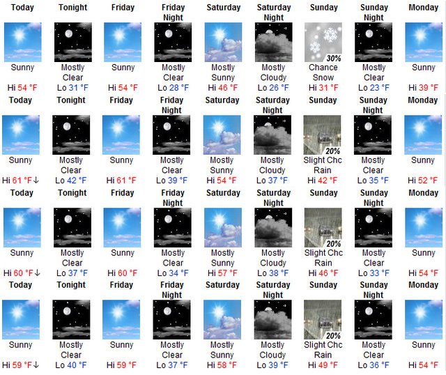
The Image Above Starts at Higher Elevations and Work Down
Hazardous Weather Outlook
HAZARDOUS WEATHER OUTLOOK
NATIONAL WEATHER SERVICE SACRAMENTO CA
700 AM PST THU JAN 27 2011
CAZ013>019-063-064-066>069-281500-
SHASTA LAKE AREA/NORTHERN SHASTA COUNTY-
BURNEY BASIN/EASTERN SHASTA COUNTY-NORTHERN SACRAMENTO VALLEY-
CENTRAL SACRAMENTO VALLEY-SOUTHERN SACRAMENTO VALLEY-
CARQUINEZ STRAIT AND DELTA-NORTHERN SAN JOAQUIN VALLEY-
MOUNTAINS SOUTHWESTERN SHASTA TO NORTHERN LAKE COUNTIES-
CLEAR LAKE/SOUTHERN LAKE COUNTY-MOTHERLODE-
EAST FOOTHILLS/NORTH SACRAMENTO VALLEY-
WESTERN PLUMAS COUNTY/LASSEN PARK-WEST SLOPE NORTHERN SIERRA NEVADA-
700 AM PST THU JAN 27 2011
THIS HAZARDOUS WEATHER OUTLOOK IS FOR INTERIOR NORTHERN CALIFORNIA.
.DAY ONE...TODAY
WIDESPREAD DENSE FOG DEVELOPED THROUGHOUT THE CENTRAL AND SOUTHERN
SACRAMENTO VALLEY...THE DELTA AND THE NORTHERN SAN JOAQUIN VALLEYS
THIS MORNING. AREAS OF DENSE FOG WILL CONTINUE THROUGH THE MORNING
HOURS. IMPROVING VISIBILITY IS EXPECTED AFTER ABOUT NOON.
* DENSE FOG ADVISORY.........SEE WWUS76 KSTO - NPWSTO FOR DETAILS *
.DAYS TWO THROUGH SEVEN... FRIDAY THROUGH WEDNESDAY
DENSE FOG WILL BE POSSIBLE AGAIN FRIDAY MORNING OVER THE CENTRAL AND
SOUTHERN SACRAMENTO VALLEY THE DELTA AND THE NORTHERN SAN JOAQUIN
VALLEYS...OTHERWISE NO HAZARDOUS WEATHER IS EXPECTED AT THIS TIME.
.SPOTTER INFORMATION STATEMENT...
WEATHER SPOTTERS ARE ENCOURAGED TO REPORT SIGNIFICANT WEATHER
CONDITIONS TO THEIR LOCAL NATIONAL WEATHER SERVICE OFFICE.
THE LATEST WEATHER INFORMATION IS AVAILABLE ON THE INTERNET AT
(LOWER CASE): HTTP://WWW.WRH.NOAA.GOV/STO
$$
|
| Comments |
| The comments are owned by the poster. We are not responsible for its content. We value free speech but remember this is a public forum and we hope that people would use common sense and decency. If you see an offensive comment please email us at news@thepinetree.net
|
| What's Related |
| These might interest you as well
Photo Albums
phpws Business Directory
Local News
- Ebbetts Pass is Now Open!
- Big Trees Market Weekly Ad, Grocery, Produce, Meat & Deli Specials Thr...
- Big Trees Market Weekly Ad, Grocery, Produce, Meat & Deli Specials Thr...
- All are Welcome to a GABA Mixer Tonight at Bear Valley Bicycles, May 9th...
- Mornings with the One Percent™ Will Return Tomorrow Morning!
- Chapel in the Pines Sunday Service, May 5, 2024
- Don't Miss the High Sierra Bike-a-Palooza on May 4th!
- The Arnold Summer Pancake Breakfasts Return for Memorial Day, July 4th...
- The 2024 Arnold Firewise Community Meeting is May 4th!
- Traffic Update...Vehicle vs Motorcycle Near Post Office on Blagen Road
Web Pages
Calendar
Link Manager
|
|
|


