|
Posted by: thepinetree on 03/13/2008 06:57 AM
Updated by: Kim_Hamilton on 03/13/2008 08:08 AM
Expires: 01/01/2013 12:00 AM
:
It has Been Raining Steadily in Arnold all Night
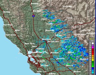
Arnold, CA...This storm was not forecast to really give us much in the way of precipitation. In Arnold however there has been steady rain for most of the night. The snow levels with this storm will start high and drop down to under 3,000ft by tomorrow night. The latest radar snapshot is below and the National Weather Service Weather Update is enclosed...

Special Weather Statement
SPECIAL WEATHER STATEMENT
NATIONAL WEATHER SERVICE SACRAMENTO CA
705 PM PDT WED MAR 12 2008
CAZ013>019-063-064-066>069-131330-
SHASTA LAKE AREA / NORTHERN SHASTA COUNTY-
BURNEY BASIN / EASTERN SHASTA COUNTY-NORTHERN SACRAMENTO VALLEY-
CENTRAL SACRAMENTO VALLEY-SOUTHERN SACRAMENTO VALLEY-
CARQUINEZ STRAIT AND DELTA-NORTHERN SAN JOAQUIN VALLEY-
MOUNTAINS SOUTHWESTERN SHASTA COUNTY TO NORTHERN LAKE COUNTY-
CLEAR LAKE/SOUTHERN LAKE COUNTY-
NORTHEAST FOOTHILLS/SACRAMENTO VALLEY-MOTHERLODE-
WESTERN PLUMAS COUNTY/LASSEN PARK-
WEST SLOPE NORTHERN SIERRA NEVADA-
705 PM PDT WED MAR 12 2008
...STORMY WEATHER DEVELOPS TONIGHT THROUGH THIS WEEKEND..
A SERIES OF LOW PRESSURE SYSTEMS WILL SPREAD MOUNTAIN SNOW AND
VALLEY RAIN SHOWERS ACROSS INTERIOR NORTHERN CALIFORNIA THROUGH THIS
WEEKEND...WITH MUCH COOLER TEMPERATURES. LIGHT RAIN IS PROBABLE
IN THE VALLEYS TONIGHT AND THURSDAY. MORE WIDESPREAD RAIN SHOWERS
ARE EXPECTED FRIDAY AND SATURDAY...WITH A CHANCE OF THUNDERSTORMS ON
SATURDAY. THESE THUNDERSTORMS MAY CONTAIN SMALL HAIL AND GUSTY
WINDS. HIGH TEMPERATURES WILL STRUGGLE TO GET OUT OF THE 50S BY
SATURDAY.
IN THE MOUNTAINS...RAIN AND SNOW WILL DEVELOP IN THE SOUTHERN
CASCADES THIS EVENING AND SPREAD SOUTH TO INTERSTATE 80 AFTER
MIDNIGHT. SNOW LEVELS WILL BEGIN NEAR 5500 FEET IN THE SHASTA COUNTY
MOUNTAINS...TO NEAR 7000 FEET ALONG INTERSTATE 80 AT DONNER SUMMIT.
A COLD FRONT ON THURSDAY WILL LOWER SNOW LEVELS TO 4000 FEET IN
SHASTA COUNTY...TO 5000 FEET ALONG INTERSTATE 80 AND HIGHWAY
50. ..THEN DOWN TO 2500 TO 3000 FEET BY FRIDAY NIGHT. GUSTY WINDS MAY
COMBINE WITH SNOW TO CREATE HAZARDOUS TRAVELING CONDITIONS IN THE
MOUNTAINS THURSDAY AND FRIDAY. MORE SNOW IS POSSIBLE SATURDAY.
HIGH PRESSURE WILL END THE PRECIPITATION BY SUNDAY. IF YOU ARE
PLANNING TO TRAVEL IN THE NORTHERN CALIFORNIA MOUNTAINS OVER THE
NEXT SEVERAL DAYS...CARRY CHAINS...EXTRA WARM CLOTHING AND WATER.
CHECK AHEAD FOR THE LATEST ROAD CONDITIONS BEFORE DEPARTING ON YOUR
TRIP. CONTINUE TO LISTEN TO NOAA WEATHER RADIO OR YOUR LOCAL MEDIA
OUTLET FOR THE LATEST CONDITIONS AND WEATHER FORECASTS.
|
| Comments |
| The comments are owned by the poster. We are not responsible for its content. We value free speech but remember this is a public forum and we hope that people would use common sense and decency. If you see an offensive comment please email us at news@thepinetree.net
|
| What's Related |
| These might interest you as well
Photo Albums
Local News
- Another Real Estate Happy Ending from Better Altitude Properties
- Big Trees Market Weekly Ad, Grocery, Produce, Meat & Deli Specials Thr...
- Arnold Chevron & Deli, Eat Where the Locals Eat! Order Lunch Today at ...
- 14.4 Million Reasons to Shop Local on Marketing Your Business! Buy Our...
- Word Wizards Converge at the 53rd Annual Calaveras County Spelling Bee...
- Uniquity Builders, Turning Your Dreams Into Reality Since 1985! Call 2...
- Your Dinner Awaits at Rossetti's @ The 19th Hole! Open Fri - Sun ...
- Big Trees Market Weekly Ad, Grocery, Produce, Meat & Deli Specials Thr...
- Chapel in the Pines Sunday Service, April 21, 2024
- Over 2,000 PG&E Customers Powerless on Sunday Morning in Our Area (Upd...
Calendar
phpws Business Directory
|
|
|


