|
Posted by: thepinetree on 09/07/2021 11:38 AM
Updated by: thepinetree on 09/07/2021 11:38 AM
Expires: 01/01/2026 12:00 AM
:
Fall is Here with Crisp Cool Mornings...Nevermind, Heat Warnings & Triple Digit Heat Until Thursday!
Arnold, CA...Well with Labor Day in the rearview mirror it is time to start think about fall. Cool crisp mornings, warm comfortable afternoons and a sweatshirt or two to take the chill out of the air in the evenings. Well that remains just a fantasy as we have triple digit temps for most of our areas and heat warnings till Thursday. The Detailed forecast for West Slope Northern Sierra Nevada. Today, Mostly sunny. Haze and patchy smoke. Highs 78 to 93 higher elevations...91 to 103 lower elevations. Prevailing east winds up to 10 mph shifting to the west in the afternoon.
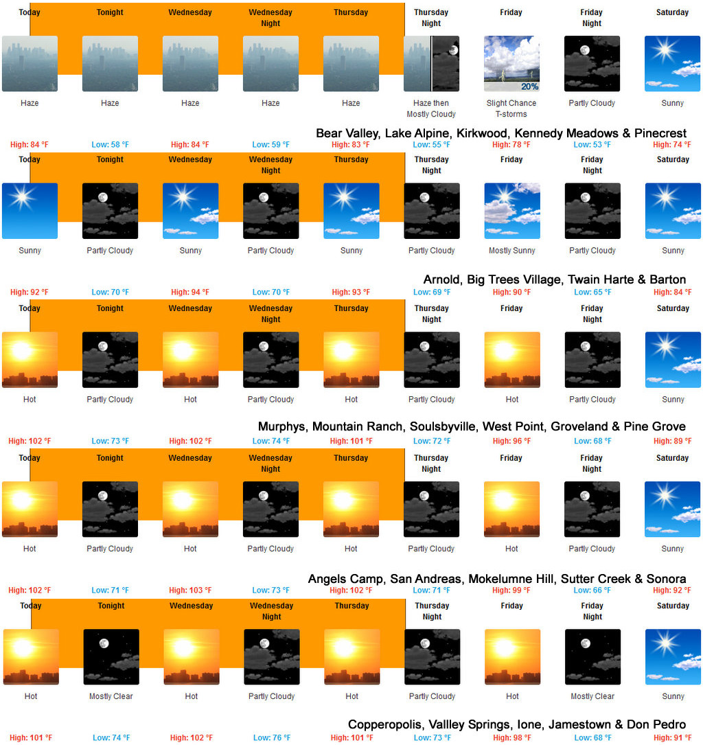
Tonight
Mostly clear. Haze and patchy smoke. Lows 53 to 68 higher elevations...63 to 76 lower elevations. Prevailing west winds 5 to 15 mph shifting to the northeast after midnight.
Wednesday
Mostly sunny. Haze and patchy smoke. Highs 79 to 94 higher elevations...92 to 104 lower elevations. Prevailing east winds up to 10 mph shifting to the west in the afternoon.
Wednesday Night
Mostly clear in the evening then becoming mostly cloudy. Haze and patchy smoke. Lows 53 to 68 higher elevations...64 to 78 lower elevations. Prevailing west winds up to 10 mph shifting to the east after midnight.
Thursday
Partly cloudy in the morning then clearing. Haze and patchy smoke. Highs 77 to 92 higher elevations...90 to 102 lower elevations. Prevailing east winds up to 10 mph shifting to the southwest in the afternoon.
Thursday Night
Partly cloudy. Haze and patchy smoke. Lows 55 to 70.
Friday
Partly cloudy with a slight chance of showers and thunderstorms. Highs 76 to 91.
Friday Night And Saturday
Mostly clear. Lows 51 to 66. Highs 74 to 89.
Saturday Night
Partly cloudy. Lows 50 to 65.
Sunday And Sunday Night
Mostly clear. Highs 71 to 86. Lows 49 to 64.
Monday
Sunny. Highs 71 to 86.
Detailed forecast for
Motherlode
Today
Haze and patchy smoke in the morning. Mostly sunny. Highs 96 to 106. Prevailing northeast winds up to 10 mph shifting to the west in the afternoon.
Tonight
Mostly clear. Lows 66 to 78. Prevailing northwest winds up to 10 mph shifting to the northeast after midnight.
Wednesday
Mostly sunny. Highs 97 to 107. Prevailing east winds up to 10 mph shifting to the west in the afternoon.
Wednesday Night
Mostly clear in the evening then becoming mostly cloudy. Lows 68 to 80. Prevailing northwest winds up to 10 mph shifting to the northeast after midnight.
Thursday
Partly cloudy in the morning then clearing. Highs 95 to 105. Prevailing east winds up to 10 mph shifting to the southwest in the afternoon.
Thursday Night
Partly cloudy. Lows 66 to 76.
Friday
Mostly sunny. Highs 90 to 100.
Friday Night
Mostly clear. Cooler. Lows 60 to 72.
Saturday
Sunny. Highs 85 to 93.
Saturday Night
Partly cloudy. Lows 58 to 70.
Sunday And Sunday Night
Mostly clear. Highs 84 to 92. Lows 57 to 70.
Monday
Sunny. Highs 84 to 92.
URGENT - WEATHER MESSAGE
National Weather Service Sacramento CA
300 AM PDT Tue Sep 7 2021
CAZ013>019-063-066>069-072300-
/O.CON.KSTO.HT.Y.0002.210907T1900Z-210910T0300Z/
Shasta Lake Area / Northern Shasta County-
Burney Basin / Eastern Shasta County-Northern Sacramento Valley-
Central Sacramento Valley-Southern Sacramento Valley-
Carquinez Strait and Delta-Northern San Joaquin Valley-
Mountains Southwestern Shasta County to Western Colusa County-
Northeast Foothills/Sacramento Valley-Motherlode-
Western Plumas County/Lassen Park-
West Slope Northern Sierra Nevada-
Including the cities of Shasta Dam, Burney, Redding, Red Bluff,
Chico, Oroville, Marysville/Yuba City, Sacramento,
Fairfield/Suisun, Stockton, Modesto, Alder Springs, Paradise,
Grass Valley, Jackson, Chester, Quincy, and Blue Canyon
300 AM PDT Tue Sep 7 2021
...HEAT ADVISORY REMAINS IN EFFECT FROM NOON TODAY TO 8 PM PDT
THURSDAY...
* WHAT...Highs in the 90s to around 105. Hottest portions of the
Central Valley will range from 105 to 110 today and Wednesday.
Mild lows only in the upper 60s to lower 80s.
* WHERE...Sacramento and northern San Joaquin Valleys, and
surrounding foothill and mountain terrain below 5000 feet
elevation.
* WHEN...From noon today to 8 PM PDT Thursday.
* IMPACTS...Heat will increase the potential for heat related
illnesses, particularly for those working or participating in
outdoor activities.
PRECAUTIONARY/PREPAREDNESS ACTIONS...
Drink plenty of fluids, stay in an air-conditioned room, stay out
of the sun, and check up on relatives and neighbors. Young
children and pets should never be left unattended in vehicles
under any circumstances.
Take extra precautions if you work or spend time outside. When
possible reschedule strenuous activities to early morning or
evening. Know the signs and symptoms of heat exhaustion and heat
stroke. Wear lightweight and loose fitting clothing when
possible. To reduce risk during outdoor work, the Occupational
Safety and Health Administration recommends scheduling frequent
rest breaks in shaded or air conditioned environments. Anyone
overcome by heat should be moved to a cool and shaded location.
Heat stroke is an emergency! Call 9 1 1.
&&
$$
|
| Comments - Make a comment |
| The comments are owned by the poster. We are not responsible for its content. We value free speech but remember this is a public forum and we hope that people would use common sense and decency. If you see an offensive comment please email us at news@thepinetree.net
No Subject
Posted on: 2021-09-07 11:49:01
By: Anonymous
|
|
Stop teasing us pinetee. Not nice :)
[Reply
]
|
Re: crisp mornings?
Posted on: 2021-09-07 18:00:28
By: Anonymous
|
|
I'm not sure about crisp, but it was 60 at 6am at our house. We're at 4300 feet.
[Reply
]
|
|
| What's Related |
| These might interest you as well
Local News
- Big Trees Market Weekly Ad, Grocery, Produce, Meat & Deli Specials Thr...
- Big Trees Market Weekly Ad, Grocery, Produce, Meat & Deli Specials Thr...
- Apres Ski at Meadow Cafe
- The Big Used XC Ski Sale Starts April 20th at Bear Valley Adventure Co...
- HCO Sledfest 2024 is April 26-28 at Bear Valley
- Big Trees Market Weekly Ad, Grocery, Produce, Meat & Deli Specials Thr...
- Getaway to Bear Valley for Closing Weekend!
- The Big Used XC Ski Sale Starts April 20th at Bear Valley Adventure Co...
- Big Trees Market Weekly Ad, Grocery, Produce, Meat & Deli Specials Thr...
Photo Albums
phpws Business Directory
Calendar
Web Pages
Link Manager
|
|
|


