|
Posted by: thepinetree on 12/06/2021 06:21 PM
Updated by: thepinetree on 12/06/2021 06:21 PM
Expires: 01/01/2026 12:00 AM
:
Winter Storm Watch Starting Wednesday Afternoon into Thursday
Arnold, CA....The National Weather Service is forecasting a Winter Storm Watch starting Wednesday afternoon..."Winter storm will bring mountain snow late Wednesday afternoon into Thursday. A storm system will approach northern California on Wednesday afternoon, bringing with it accumulating snowfall into Thursday afternoon. Snow levels start out 6000 to 7000 feet falling to 4500 to 5500 feet Thursday morning. The heaviest snow is expected Wednesday night into Thursday morning with the majority of the accumulation above 5500 feet but some light accumulation is possible down to 4500 feet. If you have mountain travel plans be prepared for winter driving conditions, chain controls, and travel delays.
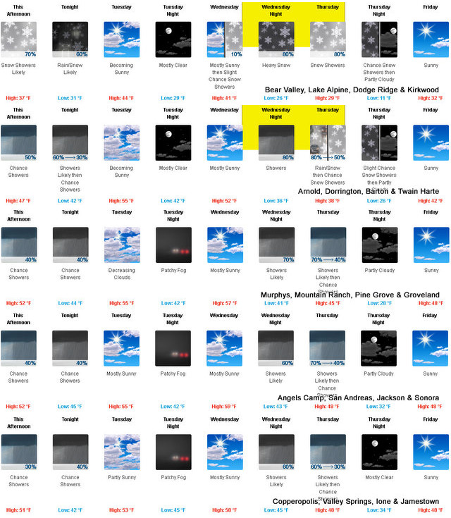
Winter Storm Watch
URGENT - WINTER WEATHER MESSAGE
National Weather Service Sacramento CA
208 PM PST Mon Dec 6 2021
...Winter storm will bring mountain snow late Wednesday afternoon
into Thursday ...
.A storm system will approach northern California on Wednesday afternoon,
bringing with it accumulating snowfall into Thursday afternoon.
Snow levels start out 6000 to 7000 feet falling to 4500 to 5500
feet Thursday morning. The heaviest snow is expected Wednesday
night into Thursday morning with the majority of the accumulation
above 5500 feet but some light accumulation is possible down to
4500 feet. If you have mountain travel plans be prepared for
winter driving conditions, chain controls, and travel delays.
CAZ068-069-071300-
/O.NEW.KSTO.WS.A.0009.211209T0000Z-211210T0000Z/
Western Plumas County/Lassen Park-
West Slope Northern Sierra Nevada-
208 PM PST Mon Dec 6 2021
...WINTER STORM WATCH IN EFFECT FROM WEDNESDAY AFTERNOON THROUGH
THURSDAY AFTERNOON ABOVE 5500 FEET...
* WHAT...Heavy snow possible. Plan on difficult travel conditions,
including during the morning commute on Thursday. Total snow
accumulations of 3 to 7 inches, with localized amounts up to 10
inches, are possible.
* WHERE...Western Plumas County/Lassen Park and West Slope
Northern Sierra Nevada.
* WHEN...From Wednesday afternoon through Thursday afternoon.
* ADDITIONAL DETAILS...Significant reductions in visibility are
possible.
PRECAUTIONARY/PREPAREDNESS ACTIONS...
A Winter Storm Watch means there is potential for significant
snow, sleet or ice accumulations that may impact travel. Continue
to monitor the latest forecasts.
$$
|
| Comments - Make a comment |
| The comments are owned by the poster. We are not responsible for its content. We value free speech but remember this is a public forum and we hope that people would use common sense and decency. If you see an offensive comment please email us at news@thepinetree.net
No Subject
Posted on: 2021-12-07 03:46:57
By: Anonymous
|
|
Fuk Donald Trump and his brainwashed racist hate filled ignorant heartless inbred trolls of the GOP!! President Biden is the best President in history!! Four More Years of Biden!! Build Back Better!! Let’s Go Joe!!
[Reply
]
|
|
| What's Related |
| These might interest you as well
Photo Albums
Local News
- Big Trees Market Weekly Ad, Grocery, Produce, Meat & Deli Specials Thr...
- Big Trees Market Weekly Ad, Grocery, Produce, Meat & Deli Specials Thr...
- HCO Sledfest 2024 is April 26-28 at Bear Valley
- Big Trees Market Weekly Ad, Grocery, Produce, Meat & Deli Specials Thr...
- Getaway to Bear Valley for Closing Weekend!
- The Big Used XC Ski Sale Starts April 20th at Bear Valley Adventure Co...
- Big Trees Market Weekly Ad, Grocery, Produce, Meat & Deli Specials Thr...
phpws Business Directory
Calendar
Link Manager
Web Pages
|
|
|


