Posted by: thepinetree on 12/26/2022 10:17 AM
Updated by: thepinetree on 12/26/2022 01:58 PM
Expires: 01/01/2027 12:00 AM
:
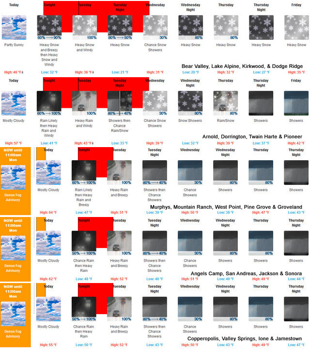
Winter Temps & Moisture Returns This Week with Up To 50 Inches of Snow at Higher Elevations
Arnold, CA...Winter Temps & Moisture Returns This Week with Up To 50 Inches of Snow at Higher Elevations. Full Details are below...

High Wind Warning
URGENT - WEATHER MESSAGE
National Weather Service Sacramento CA
640 AM PST Mon Dec 26 2022
CAZ068-069-270000-
/O.CON.KSTO.HW.W.0002.221227T0600Z-221227T1800Z/
Western Plumas County/Lassen Park-
West Slope Northern Sierra Nevada-
Including the cities of Chester, Quincy, and Blue Canyon
640 AM PST Mon Dec 26 2022
...HIGH WIND WARNING REMAINS IN EFFECT FROM 10 PM THIS EVENING TO
10 AM PST TUESDAY...
* WHAT...South winds 35 to 45 mph with gusts up to 85 mph
expected.
* WHERE...Western Plumas County/Lassen Park and West Slope
Northern Sierra Nevada.
* WHEN...From 10 PM this evening to 10 AM PST Tuesday.
* IMPACTS...Damaging winds will blow down trees and power lines.
Widespread power outages are expected. Travel will be
difficult, especially for high profile vehicles.
PRECAUTIONARY/PREPAREDNESS ACTIONS...
People should avoid being outside in forested areas and around
trees and branches. If possible, remain in the lower levels of
your home during the windstorm, and avoid windows. Use caution if
you must drive.
&&
$$
Winter Storm Warning
URGENT - WINTER WEATHER MESSAGE
National Weather Service Sacramento CA
1259 AM PST Mon Dec 26 2022
CAZ068-069-270000-
/O.UPG.KSTO.WS.A.0007.221227T1800Z-221228T1800Z/
/O.NEW.KSTO.WS.W.0009.221227T1800Z-221228T1800Z/
Western Plumas County/Lassen Park-
West Slope Northern Sierra Nevada-
Including the cities of Chester, Quincy, and Blue Canyon
1259 AM PST Mon Dec 26 2022
...WINTER STORM WARNING IN EFFECT FROM 10 AM TUESDAY TO 10 AM PST
WEDNESDAY ABOVE 5500 FEET...
* WHAT...Heavy snow expected. Total snow accumulations of 6 to 24
inches above 5500 feet, locally up to 35 inches on the higher
peaks. Winds could gust as high as 70 mph Tuesday afternoon.
* WHERE...Western Plumas County/Lassen Park and West Slope
Northern Sierra Nevada Counties.
* WHEN...From 10 AM Tuesday to 10 AM PST Wednesday.
* IMPACTS...Travel could be very difficult. Widespread blowing
snow could significantly reduce visibility. The hazardous
conditions could impact the evening commute. Very strong winds
could cause extensive tree damage.
* ADDITIONAL DETAILS...Snow levels will start out high but will be
lowering late Tuesday morning and early afternoon below major
pass levels. Heaviest snow is expected above 6000 ft. Additional
storm systems are expected throughout the week into next
weekend.
PRECAUTIONARY/PREPAREDNESS ACTIONS...
If you must travel, keep an extra flashlight, food, and water in
your vehicle in case of an emergency.
The latest road conditions for the state you are calling from can
be obtained by calling 5 1 1.
&&
$$
Hydrologic Outlook
Hydrologic Outlook
CAC003-005-007-009-011-017-021-057-061-063-067-077-089-091-095-
099-101-103-109-113-115-262000-
Hydrologic Outlook
National Weather Service Sacramento CA
1220 PM PST Sun Dec 25 2022
...Moderate to heavy rain will likely cause some urban and small
stream flooding late Monday through Tuesday...
* WHAT...A significant winter storm will impact the region late
Monday and Tuesday, with showers lingering into Wednesday. This
potent system is tapping into a very moist subtropical plume,
which will allow for periods of moderate to heavy precipitation.
Precipitation will begin in the Northern areas Monday evening,
becoming moderate to heavy Monday night, then spread south
across the region early on Tuesday. Rainfall totals will range
from 1.00 to 2.5 inches in the valley, with foothills and
mountains receiving 2.5 to 4.5 inches. Locally up to 6 inches
are possible over favored southwest facing peaks. Moderate to
heavy rain will lead to rapid rises of area rivers, streams, and
creeks. Localized ponding of water for low-lying or poorly
drained areas as well as localized flooding is possible due to
blocked drainages, and storm drains. Main stem rivers are
forecast to remain well below flood stage, but may rise above
monitor stage in a few locations.
* WHERE...Interior Northern California
* WHEN...Monday night through Tuesday with greatest impacts
expected early Tuesday. Showers will linger through Wednesday,
with runoff expected to continue.
* ADDITIONAL DETAILS...There is a concern for minor mud, rock, and
debris flows that may occur across burn areas. In addition,
strong and gusty winds are expected late Monday night and
Tuesday. Debris from gusty winds may cause drainage blockages
which could create a localized flooding threat. Localized
ponding of water is likely in low-lying or poorly drained areas,
such as freeway off ramps. No mainstem river flooding is
forecast at this time, but mainstream rivers will see rapid
rises, and may reach monitor stage in a few places. More storms
look likely late this week and into the early part of the New
Year. Please monitor the latest forecast for the most up to date
weather information.
$$
|


