Posted by: thepinetree on 01/07/2023 12:31 PM
Updated by: thepinetree on 01/07/2023 12:37 PM
Expires: 01/01/2028 12:00 AM
:
Winter Returns with a Vengeance Next Few Days! Forecasts, Winter Storm, Flood & Wind Warnings Below.
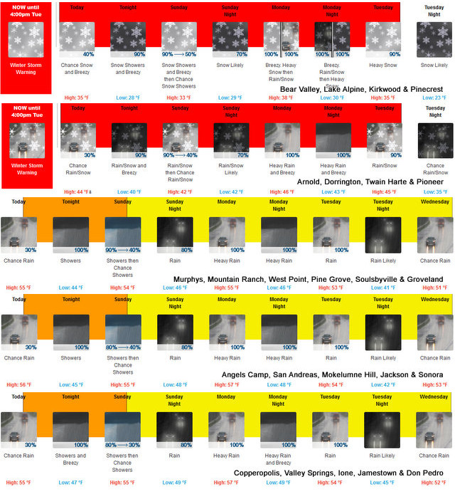
Arnold, CA...Detailed NWS forecast for the West Slope Northern Sierra Nevada. Today, Mostly cloudy. Breezy. At lower elevations, a slight chance of rain early in the morning. A chance of rain and snow late in the morning, then a chance of heavy snow showers and a slight chance of rain showers early in the afternoon. A chance of rain showers late in the afternoon. At higher elevations, a slight chance of snow early in the morning. A chance of snow late in the morning, then a slight chance of rain and snow showers early in the afternoon. A chance of snow showers and heavy rain showers late in the afternoon. Highs 28 to 43 higher elevations... 40 to 52 lower elevations. No snow accumulation lower elevations...2 to 4 inches higher elevations. Snow level 5500 feet. Prevailing south winds 5 to 15 mph increasing to 10 to 25 mph in the afternoon. Gusts up to 45 mph. Over ridges... Prevailing southwest winds 20 to 30 mph increasing to 25 to 40 mph in the afternoon.

Tonight
A chance of rain and snow showers in the evening, then heavy snow showers, rain showers and a slight chance of thunderstorms after midnight. Windy. Lows 21 to 36 higher elevations...33 to 41 lower elevations. Little or no snow accumulation lower elevations...7 to 12 inches higher elevations. Snow level 5000 feet. Prevailing south winds 15 to 30 mph with gusts to around 45 mph...except south 15 to 45 mph over ridges.
Sunday
At lower elevations, rain showers, snow showers and a slight chance of thunderstorms in the morning, then a chance of rain showers in the afternoon. At higher elevations, heavy snow showers in the morning, then a slight chance of snow showers in the afternoon. Breezy. Highs 27 to 42 higher elevations...39 to 49 lower elevations. No snow accumulation lower elevations...3 to 8 inches higher elevations. Snow level 5500 feet. Prevailing south winds 15 to 25 mph decreasing to 5 to 15 mph in the afternoon. Gusts up to 45 mph. Over ridges...prevailing southwest winds 15 to 35 mph.
Sunday Night
Mostly cloudy. A slight chance of rain and snow showers in the evening, then rain showers with heavy snow showers likely after midnight. Lows 22 to 37 higher elevations...35 to 43 lower elevations. No snow accumulation lower elevations...2 to 4 inches higher elevations. Snow level 5500 feet. Prevailing south winds 5 to 15 mph with gusts to around 35 mph...except south 10 to 30 mph over ridges.
Monday
Heavy rain showers and heavy snow showers. Breezy. Not as cool. Highs 31 to 46 higher elevations...42 to 52 lower elevations. No snow accumulation lower elevations...8 to 13 inches higher elevations. Snow level 7000 feet. Prevailing south winds 15 to 25 mph with gusts to around 50 mph...except south 15 to 45 mph over ridges.
Monday Night
Heavy rain showers, heavy snow showers and a slight chance of thunderstorms. Windy. Heavy snow accumulations possible. Lows 26 to 41.
Tuesday
Heavy snow showers, rain showers and a slight chance of thunderstorms. Breezy. Heavy snow accumulations possible. Highs 30 to 45.
Tuesday Night
Mostly cloudy with a chance of rain and snow showers. Colder. Lows 21 to 36.
Wednesday
Mostly cloudy with a chance of rain and snow showers. Highs 31 to 46.
Wednesday Night
Mostly cloudy with a chance of rain and snow showers. Lows 24 to 39.
Thursday
Mostly cloudy with a chance of rain and snow showers. Not as cool. Highs 37 to 52.
Thursday Night And Friday
Mostly cloudy with a chance of rain and snow showers. Lows 27 to 42. Highs 34 to 49.
Detailed forecast for
Motherlode
Today
Cloudy. A slight chance of rain early in the morning. A chance of rain late in the morning, then a slight chance of rain showers early in the afternoon. A chance of rain showers late in the afternoon. Highs 47 to 57. Prevailing southeast winds up to 15 mph with gusts to around 35 mph.
Tonight
A chance of rain showers in the evening, then rain showers and a slight chance of thunderstorms after midnight. Breezy. Some thunderstorms may produce heavy rainfall after midnight. Lows 37 to 47. Prevailing southeast winds 10 to 25 mph with gusts to around 50 mph.
Sunday
Rain showers and a slight chance of thunderstorms in the morning, then a chance of rain showers in the afternoon. Some thunderstorms may produce heavy rainfall in the morning. Highs 45 to 55. Prevailing south winds 10 to 20 mph. Gusts up to 50 mph decreasing to 35 mph in the afternoon.
Sunday Night
Mostly cloudy. A chance of rain showers in the evening, then rain showers after midnight. Lows 40 to 50. Prevailing southeast winds up to 15 mph with gusts to around 30 mph.
Monday
Rain showers. Breezy. Highs 49 to 57. Prevailing southeast winds 10 to 25 mph with gusts to around 45 mph.
Monday Night
Rain showers and a slight chance of thunderstorms. Some thunderstorms may produce heavy rainfall. Lows 39 to 49.
Tuesday
Rain showers and a slight chance of thunderstorms. Some thunderstorms may produce heavy rainfall. Highs 44 to 54.
Tuesday Night Through Wednesday Night
Mostly cloudy with a chance of rain showers. Lows 36 to 46. Highs 45 to 55.
Thursday And Thursday Night
Mostly cloudy with a chance of rain showers. Highs 51 to 59. Lows 38 to 49.
Friday
Mostly cloudy with rain showers likely. Highs 49 to 57.
Winter Storm Warning
URGENT - WINTER WEATHER MESSAGE
National Weather Service Sacramento CA
300 AM PST Sat Jan 7 2023
CAZ068-069-080000-
/O.CON.KSTO.WS.W.0002.230107T1200Z-230111T0000Z/
Western Plumas County/Lassen Park-
West Slope Northern Sierra Nevada-
Including the cities of Chester, Quincy, and Blue Canyon
300 AM PST Sat Jan 7 2023
...WINTER STORM WARNING REMAINS IN EFFECT UNTIL 4 PM PST
TUESDAY...
* WHAT...Heavy snow expected. Total snow accumulations of 1 to 3
feet expected this weekend with several more feet of
accumulation possible early next. Winds gusting as high as 60
mph.
* WHERE...Western Plumas County/Lassen Park and West Slope
Northern Sierra Nevada including Interstate 80 over Donner
Pass, Highway 50 over Echo Summit and Highway 88 over Carson
Pass.
* WHEN...From 4 AM Saturday to 4 PM PST Tuesday. Snow develops
today, becoming heavy tonight into Sunday morning. Heavy snow
again Monday into Tuesday.
* IMPACTS...Travel could be very difficult to impossible. Strong
winds could cause tree damage. Widespread blowing snow could
significantly reduce visibility resulting in periods of near
whiteout conditions.
* ADDITIONAL DETAILS...Snow levels will mostly be around 4000 to
5000 feet, but will gradually rise to 7000 to 8000 feet Monday
afternoon into Monday night, lowering back to around 4500 to
5000 feet Tuesday. Significant travel impacts will likely
persist at the higher pass levels on Monday. Strongest winds
will be Saturday night into Sunday morning and again Monday
through Monday night.
PRECAUTIONARY/PREPAREDNESS ACTIONS...
If you must travel, keep an extra flashlight, food, and water in
your vehicle in case of an emergency.
The latest road conditions for the state you are calling from can
be obtained by calling 5 1 1.
Flood Watch
Flood Watch
National Weather Service Sacramento CA
330 AM PST Sat Jan 7 2023
CAZ013-015>019-063-066-067-080030-
/O.CON.KSTO.FA.A.0002.230108T0800Z-230112T0000Z/
/00000.0.ER.000000T0000Z.000000T0000Z.000000T0000Z.OO/
Shasta Lake Area / Northern Shasta County-Northern Sacramento
Valley-Central Sacramento Valley-Southern Sacramento Valley-
Carquinez Strait and Delta-Northern San Joaquin Valley-Mountains
Southwestern Shasta County to Western Colusa County-Northeast
Foothills/Sacramento Valley-Motherlode-
Including the cities of Oroville, Alder Springs, Shasta Dam,
Jackson, Stockton, Grass Valley, Marysville/Yuba City, Chico, Red
Bluff, Fairfield/Suisun, Redding, Sacramento, Modesto, and
Paradise
330 AM PST Sat Jan 7 2023
...FLOOD WATCH REMAINS IN EFFECT FROM LATE SATURDAY NIGHT THROUGH
WEDNESDAY AFTERNOON...
* WHAT...Flooding caused by excessive rainfall continues to be
possible.
* WHERE...Shasta Lake Area/Northern Shasta County, Sacramento
Valley, Northern San Joaquin Valley, Carquinez Strait and Delta,
Northeast Foothills of the Sacramento Valley, Motherlode, and the
Mountains of Southwestern Shasta County to Western Colusa County.
* WHEN...From late Saturday night through Wednesday afternoon.
* IMPACTS...Excessive runoff may result in flooding of rivers,
creeks, streams, and other low-lying and flood-prone locations.
Creeks and streams may rise out of their banks. Flooding may occur
in poor drainage and urban areas. Low-water crossings may be
flooded. Storm drains and ditches may become clogged with debris.
Extensive street flooding and flooding of creeks and rivers are
possible. Area creeks and streams are running high and could flood
with more heavy rain.
* ADDITIONAL DETAILS...
- http://www.weather.gov/safety/flood
PRECAUTIONARY/PREPAREDNESS ACTIONS...
You should monitor later forecasts and be alert for possible Flood
Warnings. Those living in areas prone to flooding should be prepared
to take action should flooding develop.
&&
$$
PCH
Wind Advisory
URGENT - WEATHER MESSAGE
National Weather Service Sacramento CA
300 AM PST Sat Jan 7 2023
CAZ015>019-066-067-080000-
/O.CON.KSTO.WI.Y.0002.230107T2100Z-230108T2100Z/
Northern Sacramento Valley-Central Sacramento Valley-
Southern Sacramento Valley-Carquinez Strait and Delta-
Northern San Joaquin Valley-Northeast Foothills/Sacramento Valley-
Motherlode-
Including the cities of Redding, Red Bluff, Chico, Oroville,
Marysville/Yuba City, Sacramento, Fairfield/Suisun, Stockton,
Modesto, Paradise, Grass Valley, and Jackson
300 AM PST Sat Jan 7 2023
...WIND ADVISORY REMAINS IN EFFECT FROM 1 PM THIS AFTERNOON TO
1 PM PST SUNDAY...
* WHAT...South/southeast winds 20 to 30 mph with gusts 40 to 50
mph.
* WHERE...Sacramento Valley, Northern San Joaquin Valley,
Carquinez Strait and Delta, Northeast Foothills/Sacramento
Valley and Motherlode.
* WHEN...From 1 PM Saturday to 1 PM PST Sunday. Strongest wind
expected Saturday night into Sunday morning.
* IMPACTS...Gusty winds could blow around unsecured objects.
Tree limbs could be blown down and a few power outages may
result.
* ADDITIONAL DETAILS...Saturated soils may allow for trees to
topple more easily with gusts of this magnitude.
PRECAUTIONARY/PREPAREDNESS ACTIONS...
Use extra caution when driving, especially if operating a high
profile vehicle. Secure outdoor objects.
&&
$$
|


