|
Posted by: thepinetree on 02/02/2023 02:49 PM
Updated by: thepinetree on 02/02/2023 02:49 PM
Expires: 01/01/2028 12:00 AM
:
Winter Returns with Storm Watch & Up To 28 Inches of Snow Above 6,000 Ft.
Arnold, CA...NWS Sacramento has issued a Winter Storm Watch from Saturday afternoon through Sunday evening.. Heavy snow possible. Total snow accumulations of 6 to 15 inches above 4000 feet with 15 to 28 inches above 6000 feet. Winds could gust as high as 55 mph. The Detailed forecast for West Slope Northern Sierra Nevada. Today, Mostly sunny in the morning then becoming partly cloudy. Highs 36 to 51 higher elevations...49 to 59 lower elevations. Prevailing southeast winds 5 to 15 mph. Tonight, Mostly cloudy. Lows 21 to 36 higher elevations...34 to 44 lower elevations. Prevailing south winds 5 to 15 mph with gusts to around 35 mph...except south 10 to 30 mph over ridges.
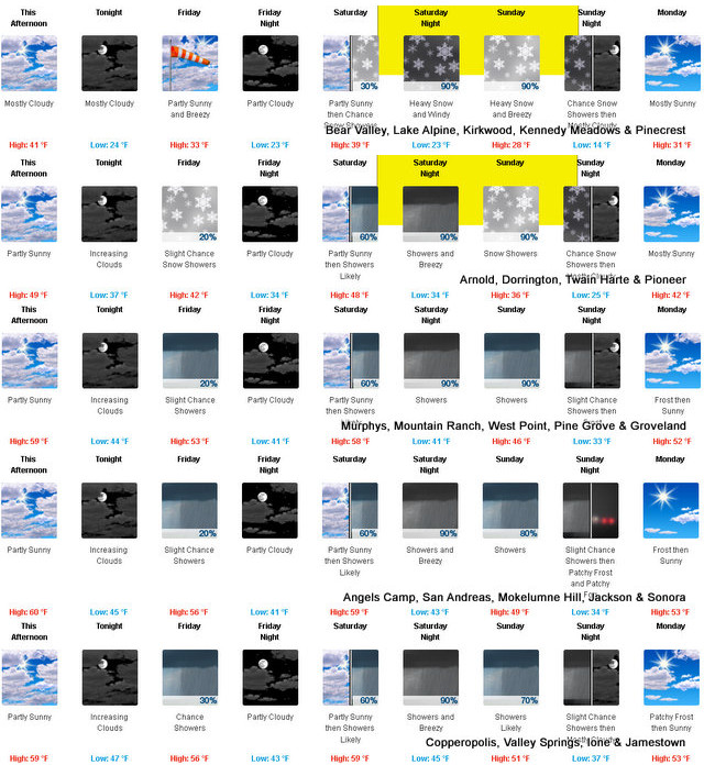

Friday
Mostly cloudy. A chance of snow showers in the morning, then a chance of rain and snow showers in the afternoon. Breezy. Highs 29 to 44 higher elevations...40 to 52 lower elevations. Little or no snow accumulation lower elevations...up to 3 inches higher elevations. Snow level 5000 feet. Prevailing south winds 10 to 25 mph with gusts to around 40 mph...except south 10 to 35 mph over ridges.
Friday Night
Mostly cloudy in the evening then becoming partly cloudy. Lows 20 to 35 higher elevations...33 to 41 lower elevations. Prevailing southeast winds up to 15 mph with gusts to around 30 mph.
Saturday
Mostly cloudy. Not as cool. Highs 34 to 49 higher elevations...45 to 57 lower elevations. Prevailing southeast winds up to 10 mph shifting to the south with gusts to around 35 mph in the afternoon.
Saturday Night
Rain showers and heavy snow showers. Windy. Heavy snow accumulations possible. Lows 23 to 38.
Sunday
Heavy snow showers, rain showers and a slight chance of thunderstorms. Breezy. Heavy snow accumulations possible. Highs 27 to 42.
Sunday Night
Mostly cloudy with a chance of snow showers. Colder. Lows 15 to 30.
Monday
Partly cloudy. Not as cool. Highs 33 to 48.
Monday Night Through Tuesday Night
Mostly clear. Lows 19 to 34. Highs 38 to 53.
Wednesday
Mostly cloudy. Highs 37 to 52.
Detailed forecast for
Motherlode
Today
Mostly sunny in the morning then becoming mostly cloudy. Highs 55 to 63. Prevailing east winds up to 10 mph shifting to the south in the afternoon.
Tonight
Mostly cloudy. Lows 38 to 48. Prevailing southeast winds up to 15 mph.
Friday
Mostly cloudy with a chance of rain showers. Highs 47 to 59. Prevailing southeast winds 5 to 15 mph.
Friday Night
Mostly cloudy in the evening then becoming partly cloudy. Lows 38 to 44. Prevailing east winds up to 10 mph.
Saturday
Mostly cloudy. Highs 52 to 62. Prevailing east winds up to 10 mph shifting to the south in the afternoon.
Saturday Night
Rain showers. Breezy. Lows 37 to 47.
Sunday
Rain showers and a slight chance of thunderstorms. Highs 41 to 53.
Sunday Night
Mostly cloudy with a slight chance of rain showers. Areas of frost. Colder. Lows 29 to 37.
Monday
Mostly sunny. Widespread frost. Not as cool. Highs 49 to 59.
Monday Night
Clear. Lows around 35.
Tuesday
Mostly sunny. Areas of frost. Highs 51 to 59.
Tuesday Night
Mostly clear. Lows 33 to 39.
Wednesday
Mostly cloudy. Highs 52 to 60.
Winter Storm Watch
URGENT - WINTER WEATHER MESSAGE
National Weather Service Sacramento CA
1156 AM PST Thu Feb 2 2023
CAZ068-069-030400-
/O.NEW.KSTO.WS.A.0003.230205T0000Z-230206T0600Z/
Western Plumas County/Lassen Park-
West Slope Northern Sierra Nevada-
Including the cities of Chester, Quincy, and Blue Canyon
1156 AM PST Thu Feb 2 2023
...WINTER STORM WATCH IN EFFECT FROM SATURDAY AFTERNOON THROUGH
SUNDAY EVENING...
* WHAT...Heavy snow possible. Total snow accumulations of 6 to 15
inches above 4000 feet with 15 to 28 inches above 6000 feet.
Winds could gust as high as 55 mph.
* WHERE...Western Plumas County/Lassen Park and West Slope
Northern Sierra Nevada Counties, including Interstate 80 over
Donner Pass, and Highway 50 over Echo Summit.
* WHEN...From Saturday afternoon through Sunday evening.
* IMPACTS...Travel could be very difficult.
* ADDITIONAL DETAILS...Snow levels initially start out between
5000 to 6000 feet Saturday and decrease to around 4000 feet
Sunday.
PRECAUTIONARY/PREPAREDNESS ACTIONS...
Monitor the latest forecasts for updates on this situation.
|
| Comments - Make a comment |
| The comments are owned by the poster. We are not responsible for its content. We value free speech but remember this is a public forum and we hope that people would use common sense and decency. If you see an offensive comment please email us at news@thepinetree.net
|
| What's Related |
| These might interest you as well
Photo Albums
Local News
- Big Trees Market Weekly Ad, Grocery, Produce, Meat & Deli Specials Thr...
- Big Trees Market Weekly Ad, Grocery, Produce, Meat & Deli Specials Thr...
- Bear Valley Music Festival ~ CVB Feature
- Bear Valley Music Festival is July 19th - August 4th! Get Your Tickets...
- Big Trees Market Weekly Ad, Grocery, Produce, Meat & Deli Specials Thr...
- Big Trees Market Weekly Ad, Grocery, Produce, Meat & Deli Specials Thr...
- Repairs Completed on Hwy 4 Over Ebbetts Pass in Time for 43rd Annual D...
- Big Trees Market Weekly Ad, Grocery, Produce, Meat & Deli Specials Thr...
phpws Business Directory
Calendar
Web Pages
Link Manager
|
|
|


