Posted by: thepinetree on 07/19/2023 01:46 PM
Updated by: thepinetree on 07/19/2023 02:38 PM
Expires: 01/01/2028 12:00 AM
:
After a "Cool" Week Heat Advisories Return for the Weekend
Arnold, CA...Mother Nature has heard your complaints that you have been shivering in the frigid weather the last few days. The comforting heat advisories return for the weekend. The latest forecasts for the West Slope and Mother Lode are below as well as the heat advisory. Stay Cool and remember that it is typically 20 - 25 degrees cooler in the high county.
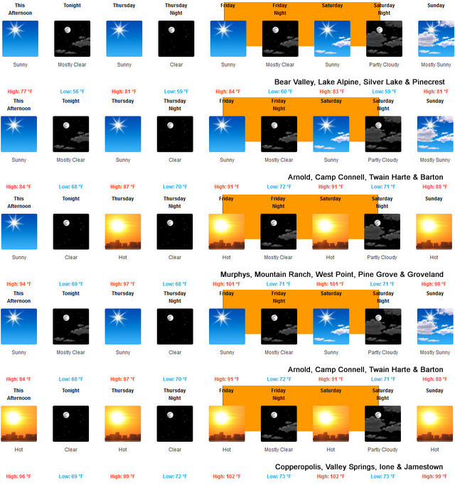

Detailed forecast for
West Slope Northern Sierra Nevada
Today
Sunny. Highs 71 to 86 higher elevations...84 to 94 lower elevations. Prevailing southeast winds up to 10 mph shifting to the southwest in the afternoon.
Tonight
Clear. Lows 50 to 65 higher elevations...60 to 75 lower elevations. Prevailing southwest winds up to 10 mph shifting to the east after midnight.
Thursday
Sunny, warmer. Highs 74 to 89 higher elevations... 87 to 97 lower elevations. Prevailing southeast winds up to 10 mph shifting to the southwest in the afternoon.
Thursday Night
Clear. Lows 52 to 67 higher elevations...61 to 76 lower elevations. Prevailing west winds up to 10 mph shifting to the east after midnight.
Friday
Sunny, warmer. Highs 78 to 93 higher elevations...90 to 102 lower elevations. Prevailing east winds up to 10 mph shifting to the southwest in the afternoon.
Friday Night
Mostly clear. Lows 58 to 73.
Saturday
Mostly sunny. Highs 81 to 96.
Saturday Night Through Monday
Mostly clear. Lows 56 to 71. Highs 78 to 93.
Monday Night And Tuesday
Clear. Lows 52 to 67. Highs 75 to 90.
Detailed forecast for
Motherlode
Today
Sunny. Highs 88 to 98. Prevailing southeast winds up to 10 mph shifting to the southwest in the afternoon.
Tonight
Clear. Lows 62 to 74. Prevailing southwest winds up to 10 mph in the evening becoming light.
Thursday
Sunny. Highs 92 to 102. Light winds becoming west up to 10 mph in the afternoon.
Thursday Night
Clear. Lows 65 to 75. Prevailing west winds up to 10 mph shifting to the northeast after midnight.
Friday
Sunny. Highs 96 to 106. Prevailing northeast winds up to 10 mph shifting to the west in the afternoon.
Friday Night
Clear. Lows 67 to 77.
Saturday
Sunny. Highs 95 to 105.
Saturday Night Through Sunday Night
Mostly clear. Lows 64 to 75. Highs 92 to 105.
Monday Through Tuesday
Clear. Highs 88 to 98. Lows 61 to 72.
URGENT - WEATHER MESSAGE
National Weather Service Sacramento CA
1232 PM PDT Wed Jul 19 2023
CAZ013-015>019-063-066>069-201200-
/O.NEW.KSTO.HT.Y.0003.230721T1800Z-230723T0600Z/
Shasta Lake Area / Northern Shasta County-
Northern Sacramento Valley-Central Sacramento Valley-
Southern Sacramento Valley-Carquinez Strait and Delta-
Northern San Joaquin Valley-
Mountains Southwestern Shasta County to Western Colusa County-
Northeast Foothills/Sacramento Valley-Motherlode-
Western Plumas County/Lassen Park-
West Slope Northern Sierra Nevada-
Including the cities of Shasta Dam, Redding, Red Bluff, Chico,
Oroville, Marysville/Yuba City, Sacramento, Fairfield/Suisun,
Stockton, Modesto, Alder Springs, Paradise, Grass Valley,
Jackson, Chester, Quincy, and Blue Canyon
1232 PM PDT Wed Jul 19 2023
...HEAT ADVISORY IN EFFECT FROM 11 AM FRIDAY TO 11 PM PDT
SATURDAY...
* WHAT...High temperatures of up to 99 to 111 expected. Very warm
overnight lows in the 60s to upper 70s.
* WHERE...Sacramento Valley, northern San Joaquin Valley, Delta
Area, Motherlode, Northeast Foothills, Mountains of Southwestern
Shasta County to Western Colusa County, Shasta County Mountains,
Western Plumas County, and portions of the West Slope Sierra
Nevada below 6000 feet.
* WHEN...From 11 AM Friday to 11 PM PDT Saturday.
* IMPACTS...Hot temperatures may cause heat illnesses to occur.
* ADDITIONAL DETAILS...Widespread Moderate HeatRisk with areas of
Major HeatRisk expected. Warmest overnight lows in the northern
and central Sacramento Valley and foothills.
PRECAUTIONARY/PREPAREDNESS ACTIONS...
Drink plenty of fluids, stay in an air-conditioned room, stay out
of the sun, and check up on relatives and neighbors. Young
children and pets should never be left unattended in vehicles
under any circumstances.
Take extra precautions if you work or spend time outside. When
possible reschedule strenuous activities to early morning or
evening. Know the signs and symptoms of heat exhaustion and heat
stroke. Wear lightweight and loose fitting clothing when
possible. To reduce risk during outdoor work, the Occupational
Safety and Health Administration recommends scheduling frequent
rest breaks in shaded or air conditioned environments. Anyone
overcome by heat should be moved to a cool and shaded location.
Heat stroke is an emergency! Call 9 1 1.
&&
|


