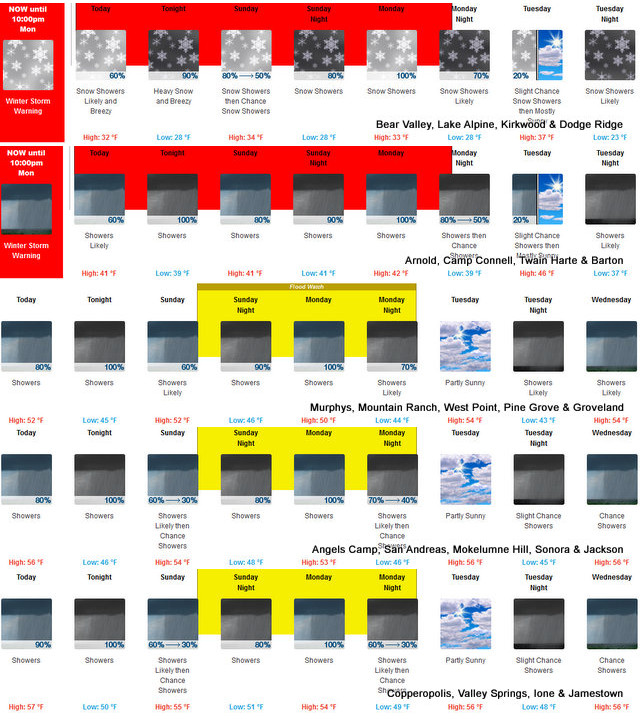
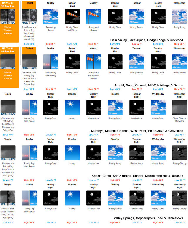
Winter Storm Warnings for Mountains & Flood Watch for Mother Lode
Posted by: thepinetree on 01/20/2024 01:54 PM
Arnold, CA...Detailed forecast from the National Weather Service for West Slope Northern Sierra Nevada. Tonight, At lower elevations, rain showers. At higher elevations, rain and snow showers until early morning, then heavy rain and snow showers likely late in the night. Colder. Lows 23 to 38 higher elevations...34 to 44 lower elevations. No snow accumulation lower elevations...1 to 7 inches higher elevations. Snow level 6500 feet. Prevailing south winds 10 to 20 mph with gusts to around 35 mph. Over ridges, prevailing southwest winds 20 to 35 mph decreasing to 15 to 25 mph after midnight.
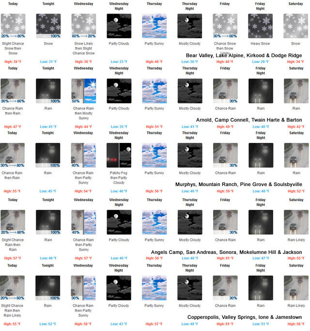
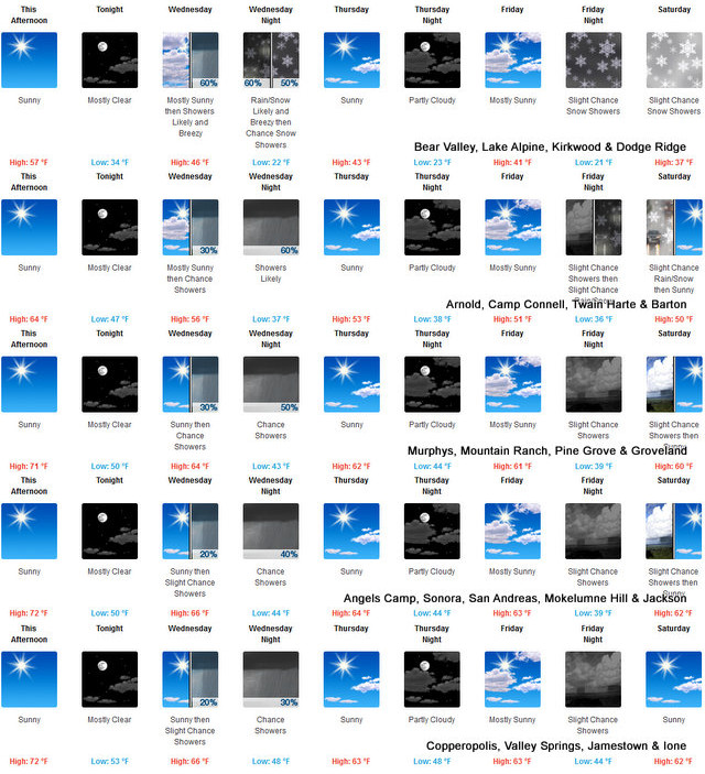
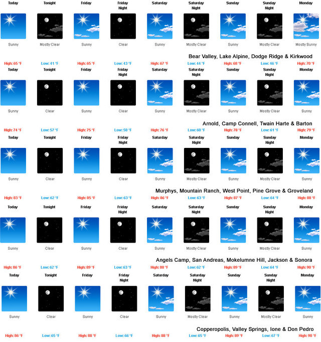
A Bit More Moisture for the West Slope & Mother Lode
Posted by: thepinetree on 01/16/2024 10:18 AM
Arnold, CA...This is the latest Detailed forecast from the National Weather Service for
West Slope Northern Sierra Nevada. Today, Mostly cloudy. At lower elevations, a chance of rain in the afternoon. At higher elevations, a chance of rain and snow in the afternoon. Highs 34 to 49 higher elevations...45 to 55 lower elevations. Snow level 7000 feet. Prevailing east winds up to 10 mph shifting to the south in the afternoon. Gusts up to 25 mph. Over ridges...prevailing southwest winds 5 to 15 mph increasing to 15 to 25 mph in the afternoon.
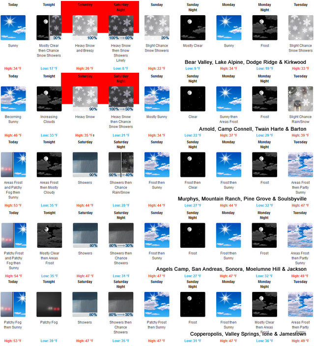
Storm Door is Open, Winter Storm Warning Sat & Sun, Up to 2 Feet of Snow, Snow Level as Low as 1,500 Feet.
Posted by: thepinetree on 01/05/2024 10:03 AM
Arnold, CA...The Latest from the National Weather Service...Heavy snow. Total snow accumulations of 1 to 2 feet. Winds gusting as high as 55 mph. Snow levels around 2,000 to 3,000 feet Saturday afternoon, reaching as low as 1,500 feet Sunday morning. Snow rates of 2 inches per hour are possible.
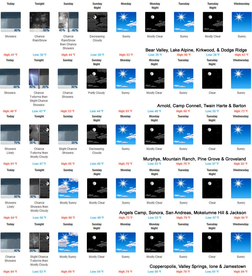
Snow in the High Country, Rain in the Foothills as December Rolls In
Posted by: thepinetree on 11/30/2023 04:03 PM
Arnold, CA...As this series of weather systems rolls through it will bring snow above 5,000 ft and rain below. The full forecasts from the National Weather Service for this weekend are below...
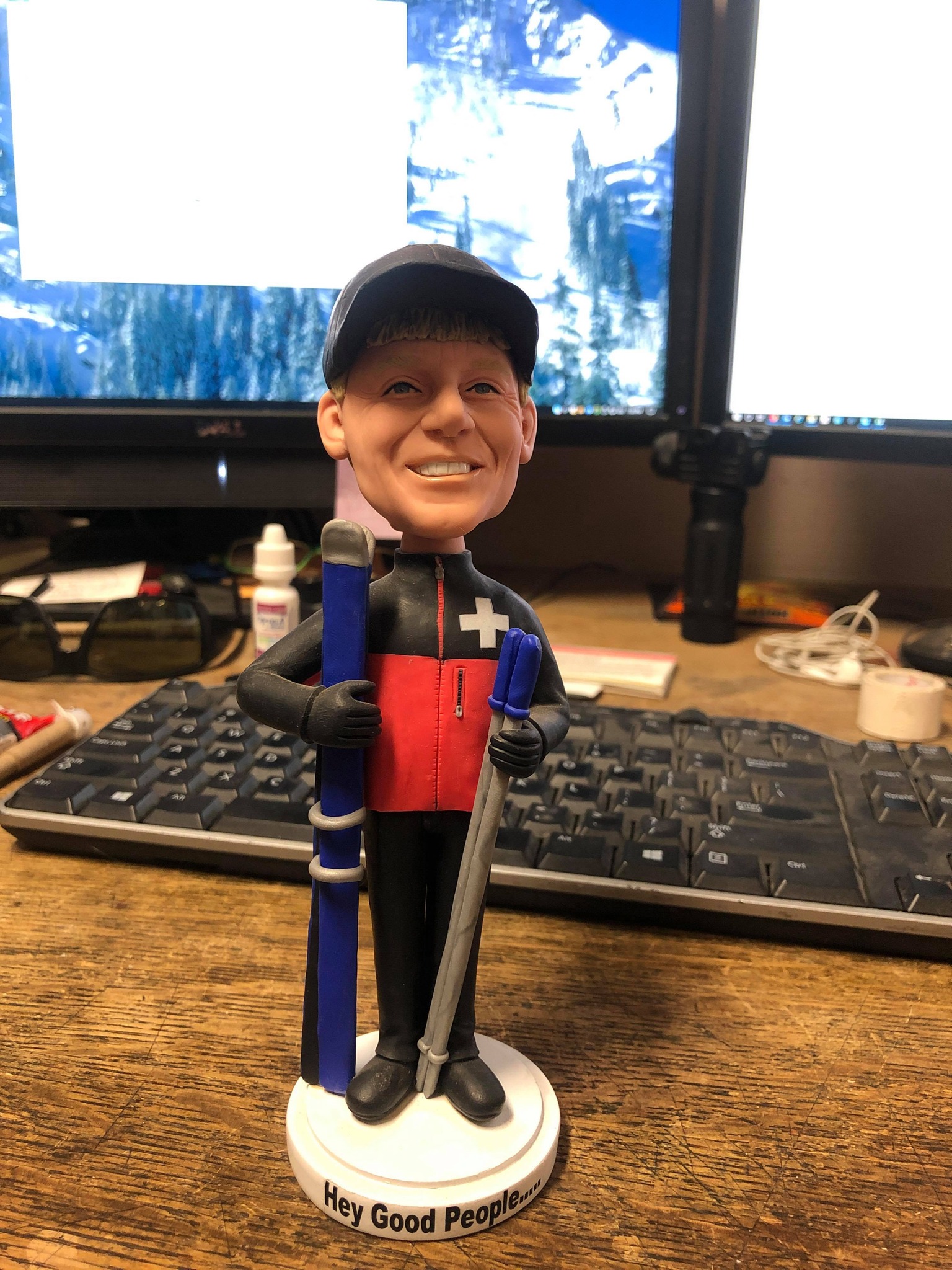
Hey Good People! It's Snowing in Bear Valley & The Bear is Back! ~ Mattly Trent
Posted by: thepinetree on 11/18/2023 11:00 AM
Bear Valley, CA...Hey Good People! It’s snowing currently at 5am at 7500′ as the system begins to offload moisture over the forecast area. Winds look to increase this morning so we will see those values push into the 20’s by mid-morning and possibly ramp up into the 30’s by mid-day. Things are still a bit warmer than we all would like with this system but the good news is we may see 3-5″ fall at the resort by days end with the similar amount falling tonight.
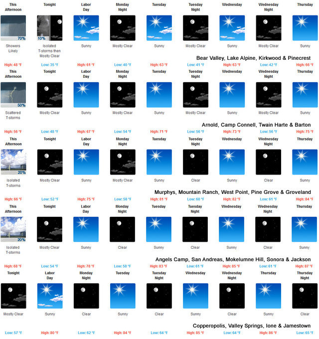
Rain & Snow Continues Overnight Then Clearing for Thanksgiving Week
Posted by: thepinetree on 11/18/2023 06:47 PM
Arnold, CA...Rain & Snow Continues Overnight Then Clearing for Thanksgiving Week. Full detailed forecasts for the West Slope & Mother Lode from the National Weather Service are below...
Who's Dreaming of a White Halloween? Colder Wetter Weather Ahead
Posted by: thepinetree on 10/24/2023 03:08 PM
Arnold, CA...Who's Dreaming of a White Halloween? Colder Wetter Weather Ahead and I for one am not ready for snow yet. Christmas yes, Halloween is a bit early. The latest forecasts from the National Weather Service for the West Slope & Mother Lode are below...
It's Sept. 30 & Wax Those Skis! Chance of Snow Showers in the High Country
Posted by: thepinetree on 09/30/2023 11:00 AM
Arnold, CA...Ladies, Gents, Boys & Girls...the Calendar may say it's still September but there is actually a chance of snow in the high country. Detailed forecasts from the National Weather Service for the West Slope & Mother Lode are below. Enjoy...
The Perfect Weather Weekend Awaits for Labor Day 2.O
Posted by: thepinetree on 09/07/2023 10:01 AM
Arnold, CA...Well did Mother Nature rain & chill your Labor Day plans? No worries Labor Day 2023 2.0 is ahead for this weekend. Absolutely perfect weather for all you outdoor adventures awaits in our area. Details from the NWS for the West Slope and Mother Lode are below...