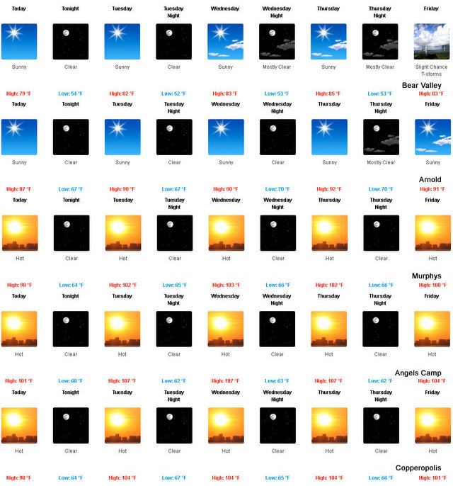
It's A Triple Digit Week! Time To Head For The Hills
Posted by: thepinetree on 07/25/2016 09:12 AM
Arnold, CA...Well it looks like a fire danger and triple digit week at lower elevations. Nature's air conditioner can drops temps up to 25 degrees in the high country. Today: Sunny. Highs 72 to 87 higher elevations...85 to 95 lower elevations. Prevailing east winds up to 10 mph shifting to the southwest in the afternoon. Tonight: Clear. Lows 49 to 64 higher elevations...62 to 72 lower elevations. Prevailing west winds up to 10 mph shifting to the east after midnight. Tuesday: Sunny...wmer. Highs 75 to 90 higher elevations... 89 to 97 lower elevations. Prevailing east winds up to 10 mph shifting to the southwest in the afternoon.
Summer Is Here, Head For The Hills! Mother Nature's Air Conditioner!
Posted by: thepinetree on 06/20/2016 01:45 PM
Arnold, CA...Things are starting to heat up at lower elevations along the West Slope Northern Sierra Nevada. Today Sunny...warmer. Highs 67 to 82 higher elevations...79 to 91 lower elevations. Prevailing southeast winds up to 10 mph shifting to the southwest in the afternoon. Tonight Mostly clear. Lows 48 to 63 higher elevations...58 to 70 lower elevations. Prevailing southwest winds up to 10 mph shifting to the southeast after midnight.
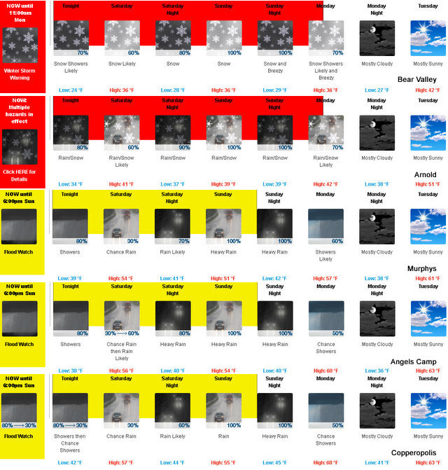
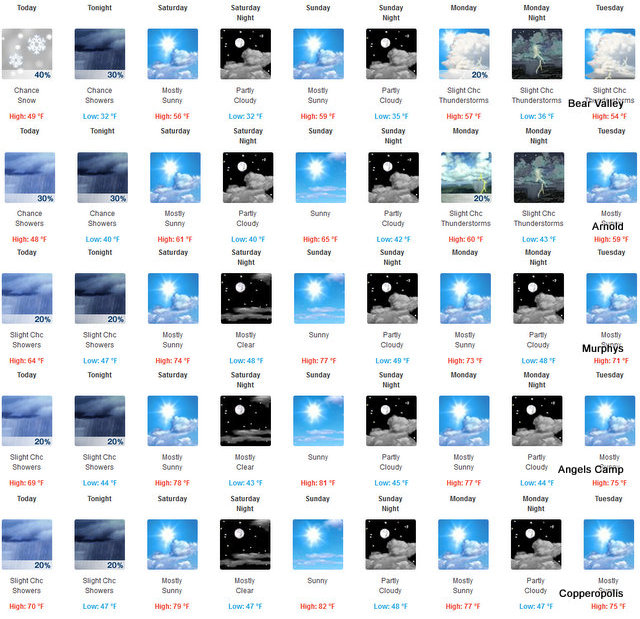
Miracle March Continues On - Time To Fill New Melones
Posted by: thepinetree on 03/11/2016 08:38 PM
Bear Valley, CA...Rest Of Tonight Rain and snow showers likely. Colder. Lows 21 to 35 higher elevations...34 to 40 lower elevations. No new snow accumulation lower elevations...except new snow accumulation of 1 to 3 inches higher elevations. Snow level 5000 feet. Prevailing south winds 5 to 15 mph. Saturday Cloudy with a chance of rain and snow. Highs 28 to 42 higher elevations...38 to 50 lower elevations. No snow accumulation lower elevations...3 to 5 inches higher elevations. Snow level 5000 feet. Prevailing south winds 10 to 20 mph.
Flood Watch Issued For Areas Including Calaveras County From Late Tonight Through Sunday Afternoon
Posted by: thepinetree on 03/09/2016 06:33 PM
San Andreas, CA...National Weather Service in Sacramento has issued a flood watch for a portion of Northern California including Calaveras County from late tonight through Sunday afternoon. Saturated soils and swollen small creeks and streams from recent rains have primed the area for potential flooding with the approaching storms. A series of storms will bring the potential for widespread nuisance flooding to low lying areas, ponding of water on roadways, and flooding of streams and creeks.
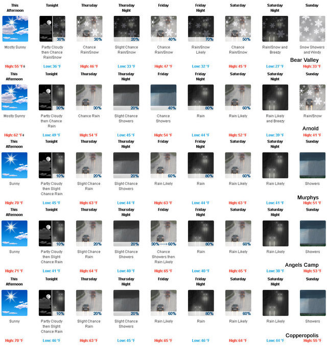
Winter Kinda, Sorta Returns This Week. Storm Door Projected To Open Back Up Next Week
Posted by: thepinetree on 03/02/2016 01:21 PM
Arnold, CA...Today Mostly sunny. Warmer. Highs 48 to 63 higher elevations... 60 to 68 lower elevations. Prevailing south winds up to 15 mph. Tonight Partly cloudy in the evening...then mostly cloudy with a slight chance of rain or higher elevation snow after midnight. Lows 32 to 47 higher elevations...42 to 52 lower elevations. Prevailing south winds 5 to 15 mph with gusts to around 30 mph...except southwest 15 to 30 mph over ridges.
Details Of Magnitude 7.1 Iniskin Earthquake ~ By Ian Dickson Alaska Earthquake Center
Posted by: thepinetree on 01/25/2016 01:21 AM
Fairbanks, AK...A damaging magnitude 7.1 earthquake occurred at 1:30am Sunday, 60 miles west of Homer. So far there are no reports of injuries. According to KTUU, gas leaks on Lilac Lane in Kenai resulted in one house fire and the evacuation of residents from 20 or so homes to the National Guard armory. The earthquake also damaged Kalifornsky Beach Road about a mile from the Sterling Highway and caused power outages affecting over 10,000 homes across Southcentral Alaska.
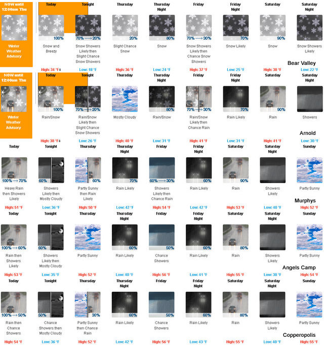
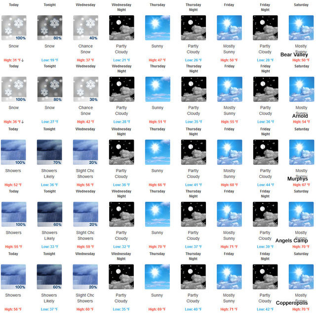
Mother Nature Opened The Storm Door For Fresh Snow For MLK Weekend
Posted by: thepinetree on 01/13/2016 08:13 AM
Arnold, CA...The National Weather Service Forecast For The West Slope Northern Sierra Nevada is: Today: Snow and heavy rain in the morning...then rain and snow showers in the afternoon. Breezy. Highs 29 to 41 higher elevations...38 to 46 lower elevations. No snow accumulation lower elevations...6 to 11 inches higher elevations. Snow level 5000 feet. Prevailing south winds 10 to 25 mph with gusts to around 40 mph...except southwest 25 to 40 mph over ridges. Tonight: Mostly cloudy. Rain and snow showers in the evening... Then a chance of rain and snow showers after midnight. Colder. Lows 16 to 31 higher elevations...28 to 36 lower elevations. No snow accumulation lower elevations...1 to 3 inches higher elevations. Snow level 5000 feet decreasing to 4000 feet after midnight. Prevailing south winds up to 15 mph with gusts to around 30 mph. Over ridges...prevailing southwest winds 20 to 30 mph decreasing to 5 to 15 mph after midnight.
Arnold, CA...Today..Mostly cloudy. A chance of rain and snow showers in the morning... Then a chance of rain showers...snow showers and a slight chance of thunderstorms in the afternoon. Not as cool. Highs 42 to 57 higher elevations...52 to 66 lower elevations. Snow level 6500 feet increasing to 7500 feet in the afternoon. Prevailing northeast winds up to 10 mph shifting to the west in the afternoon. Tonight, Mostly cloudy in the evening then becoming partly cloudy. A chance of rain showers...snow showers and a slight chance of thunderstorms in the evening. Lows 29 to 44 higher elevations...40 to 50 lower elevations. Snow level above 8000 feet. Prevailing west winds up to 10 mph in the evening becoming light...
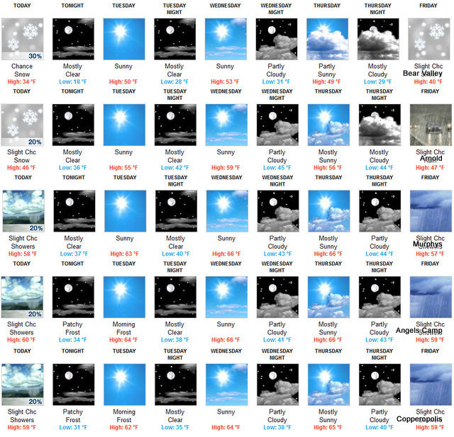
Winter Storm Warning Until Midnight. Snow Level Rising To 4500 Feet Tomorrow
Posted by: thepinetree on 04/07/2015 11:35 AM
Arnold, CA...Snow showers. Highs 24 to 39 higher elevations...38 to 48 lower elevations. Snow accumulation of 4 to 9 inches. Prevailing south winds 5 to 15 mph with gusts to around 30 mph... Except southwest 20 to 30 mph over ridges. Tonight Rain and snow showers. Colder. Lows 15 to 29 higher elevations...27 to 35 lower elevations. Snow accumulation of 2 to 4 inches. Snow level 3500 feet. Prevailing southwest winds up to 15 mph...except southwest 15 to 25 mph over ridges.
Wednesday...
Weather System To Clear Out After Today...Next System To Appear This Weekend
Posted by: thepinetree on 02/23/2015 07:36 AM
Bear Valley, CA...Today Partly cloudy in the morning then becoming mostly sunny. A chance of snow showers. Breezy. Highs 30 to 45 higher elevations...47 to 55 lower elevations. Prevailing east winds 10 to 25 mph. Gusts to around 45 mph. Tonight Clear. Lows 17 to 32 higher elevations...31 to 41 lower elevations. Prevailing east winds 10 to 20 mph. Tuesday Sunny. Not as cool. Highs 43 to 58 higher elevations... 56 to 64 lower elevations. Prevailing northeast winds up to 15 mph.
Tuesday Night Clear. Lows 26 to 41 higher elevations...36 to 46 lower elevations. Light winds becoming northeast up to 10 mph after midnight...